
Passerine Pavilion at Wells Overlook Park
Audio Tour
The audio recordings below are readings of each of the panels located on site at the Wells Overlook Passerine Pavilion. There are nine panels in total, each with a corresponding reading.
Acknowledgements
Transcription of Passerine Audio Tour - Acknowledgements
Acknowledgements
The construction of the passerine pavilion was made possible through funding from Douglas County and a land and water conservation fund grant from the National Park Service in 1970 William H wells donated. 16 acres to Douglas County to create wells overlook park in order to provide the area with an unparalleled view of the Wakarusa River. Valley mount oread KU and other parts of Douglas County visible from the prominent hill wells also wanted to honor his father Charles and his grandfather William Dougal wells who at age 19 came to help establish Lawrence. Arriving in the area as part of the 3rd party of the New England immigrant aid society in October 1854. For Douglas County constructed the tower access road and other amenities and dedicated it in October 1974 quote with the thought that it could be kept as natural as possible and as a recreation area for the public End Quote. Generous support in the form of in-kind donations was provided by local business HMC performance coding design services were provided by the University of Kansas dirt works. CEO and engineering by Douglas County public works dirt works studio constructed the pavilion with assistance from Douglas County public works in addition to the students of the dirt works studio 2020 spring we would like to acknowledge the assistance of dirt. Works studio 2020 fall for lending a helping hand to bring the project to fruition special thanks go to Ken Lassman whose dedication to the land guided the project through every stage. To Jan shepherd Eric heritage coordinator at Douglas County heritage conservation council for her assistance in researching for the waysides to the Master Gardeners of Douglas County for their contributions to the Prairie demonstration garden. Karl Ramberg for his inspiration to Douglas County public works including Keith Browning Chad void Doug Stephens Alan Hollinger and to everyone else who provided valuable contributions along the way.
Brought to you by the Heritage Conservation Council
Learn more at the HCC Website
Panel One: Overview of Project
Transcription of Passerine Audio Tour - Overview of Project
Panel One - Overview
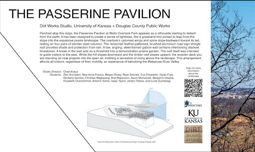
The Passerine Pavilion a collaboration between the University of Kansas 's dirt works studio and Douglas County public works. Perched atop this Ridge the passerine pavilion at wells overlook park appears as a silhouette starting to detach from the earth. It has been designed to create a sense of lightness like a grassland bird poised to leap from the slope into the expansive Prairie landscape. The overlooks upturned wings and spine slope backward toward its tail resting on 4 pairs of slender steel columns. The reclaimed feather patterned brushed aluminum road sign shingle roof provides shade and protection from rain a low angling steel framed gabion wall contains interlocking stacked limestones. A break in the wall acts as a threshold into a demonstration Prairie garden. The wall itself was intended to guide visitors to the east. While the hill slopes downward and the timber roof slopes upward the wooden deck you are standing on now projects into the open air instilling a sensation of rising above the landscape. This arrangement affords all visitors regardless of their mobility and experience of beholding the Wakarusa River Valley. Studio director Chad Krause. Students Levi Arenstein Max Avila Franco. Meghan brewery. Ryan Daniels. Eva Elias Dutour. Dylan Frye. Kimberly Gordon. Christian Magnussen. Brett Mahara icon. Erin Michalicek. Benjamin Obadiah. Elizabeth Overshift. Antonin Some. Isaac Taylor. Jordan Tobias and Lucy Zumsteg. Sponsored by the National Park Service Land and Water Conservation Fund Douglas County the University of Kansas and Derrick Studio.
Panel Two - KU Campus, Santa Fe RR and River Valleys
Transcription of Passerine Audio Tour - KU Campus, Santa Fe RR and River Valleys
Panel Two - KU Campus, Santa Fe RR and River Valleys
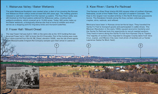
Wakarusa Valley/Baker Wetlands: The wide Wakarusa floodplain was created when a dam of ice crossing the Kansas and Wakarusa river valleys broke at least 600,000 years ago. The melting glaciers released a vast lake created from the backed-up waters the car River Valley was still blocked so the floodwaters widened the Wakarusa valley creating ideal wetland conditions which covered up to 13,000 acres. Today 9:00 100 acres make up the Baker wetlands a biologically diverse site that is home to wildlife and which serves as a stopping point for a migratory birds and monarch butterflies. 2 Fraser Hall mount Orion the new Fraser Hall was built in 1965 on the same side as the 1872 building that was renamed Fraser Hall in 1897 to honor the SKU chancellor part of the building. Was made from a stone quarried from this hill mount oread elevation 1030 feet was the site where agents of the Massachusetts emigrant aid company camped upon their arrival in Lawrence? Yes. 3 car river Santa Fe railroad the Kansas or car river drained 60,000 square miles of northern Kansas Nebraska South of the Platte River and part of eastern Colorado. The car is the largest river located entirely in the North American grasslands Biome the floodplain forest along the cog contained cottonwoods, maples, elms, walnuts, and willows. Mexicans have been in Kansas since territorial days they traveled the Santa Fe trail to transport goods and participated in cattle drives the Mexican revolution in the early 1900s caused economic hardship and the Santa Fe railroad took the opportunity to recruit needed. Workers. They lived in towns along the Santa Fe line from Kansas City to Topeka the majority of workers who migrated to Douglas County were from Veracruz Juarez and Mexico City see the photo insert of workers at the Lawrence Santa Fe railyard.
Panel Three - Haskell, Blanton's Crossing and Franklin, KS
Transcription of Passerine Audio Tour - Haskell, Blanton's Crossing and Franklin, KS
Panel Three - Haskell, Blanton's Crossing and Franklin, KS
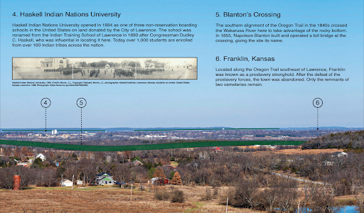
Haskell Indian Nations University opened in 1884 as one of 3 non reservation boarding schools in the United States on land donated by the City of Lawrence. The school was renamed from the Indian Trading School of Lawrence in 1890 after congressman Dudley C. Haskell, who was influential in locating it here today. Over 100,000 have enrolled from over 100 Indian tribes across the nation.
Blanton 's Crossing - the southern alignment of the Oregon trail in the 1840s crossed the Wakarusa River here to take advantage of the rocky bottom. In 1855, Napoleon Blanton built and operated a toll bridge at the crossing, giving the site its name.
Franklin, Kansas - Located along the Oregon trail southeast of Lawrence, Franklin was known as a pro-slavery stronghold after the defeat of the pro slavery forces the town was the abandoned only the remnants of 2 cemeteries remain.
Panel Four - African American History
Transcription of Passerine Audio Tour - African American History
Panel Four - African American History
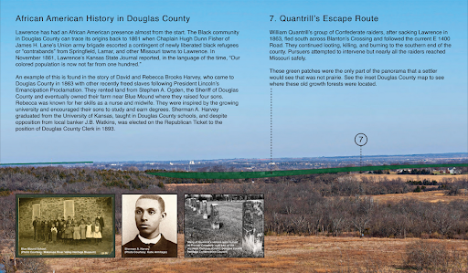
4th panel from the left. African American history in Douglas County. Lawrence has had an African American presence almost from the start the black community in Douglas County can trace its origins back to 1860. Fun when Chaplin Hugh Dunn Fisher of James H lanes union army brigade escorted a contingent of newly liberated black refugees or contrabands from Springfield Lamar and other Missouri towns to Lawrence. In November 1861, Lawrence’s Kansas State Journal reported in the language of the time,"Our colored population is now not far from 100”. An example of this is found in the story of David and Rebecca brooks Harvey who came to Douglas County in 1863 with other recently freed slaves. Following president Lincoln 's Emancipation Proclamation. They rented land from Stephen A Ogden the sheriff of Douglas County and eventually owned their farm near blue mound where they raised 4 sons Rebecca was known for her skills as a nurse and midwife, they were inspired by the growing university and encouraged their sons to study. An earned degree. Please Sherman a Harvey graduated from the University of Kansas taught in Douglas County schools and despite opposition from local banker JP Watkins was elected on the republican ticket to the position of Douglas County clerk in. 1893. Quantrill 's escape route. William Quantrill 's group of confederate Raiders after sacking Lawrence in 1863 fled South across Blanton’s Crossing and followed the current east 1400 road they continued looting killing and burning. To the southern end of the county 's pursuers attempted to intervene, but nearly all the Raiders reached Missouri safe. Green shadings on the panorama photos were the only part of the landscape that a settler would see that was not Prairie see the insect Douglas County map to see where these old growth forests were located.
Panel Five - Blue Mound, Eudora and Oregon Trail
Transcription of Passerine Audio Tour - Blue Mound, Eudora and Oregon Trail
Panel Five - Blue Mound, Eudora and Oregon Trail
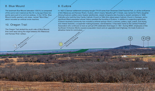
Blue Mound
the landmark blue mound elevation 1052 feet is composed of the same rock material as this hill long ago these 2 points were part of a common plateau. In the 1970s blue mound briefly sported the ski slope named mount blue which included an artificial snow machine.
Eudora
In 1857 a German settlement company bought 774 and 1/2 acres from Shawnee chief Pascal fish junior at the confluence of the Wakarusa and Kansas rivers eudora which means beautiful gift. And Greek was named for fishe daughter among eudora settlers were Quaker abolitionists Jewish immigrants who founded a Jewish cemetery in 1858. Catholics who built the Holy Family Catholic Church in 1864 the oldest extant Catholic Church in Kansas and a significant black population whose history parallels the founding of eudora in addition to supporting agriculture. Eudorus business community has included a mineral springs resort a cannery pottery cigar match fruit drying and cheese factories a suspender making business and breweries it has been home to the central protection association. Which continues to host an annual CPA celebration that began in 1901 during World War 2 employees of the sunflower ordinance works caused a population boom and an upgraded road highway 10 made eudora an attractive home for commuters?
The Oregon Trail
The Oregon trail skirted the South side of blue mound then went West along the Ridge between the Wakarusa and Kansas river valleys.
Panel Six - Hercules/Sunflower Ordnance Works
Transcription of Passerine Audio Tour - Hercules/Sunflower Ordnance Works
Panel Six - Hercules/Sunflower Ordnance Works
As the U.S. joined World War 2, 2500 young men and women from Douglas County went to war to serve their country in 1942. The U.S. government began building the Sunflower Ordinance Works. 150 small farms were purchased to create the largest rocket propellant plant in the world over 3000 workers moved to the area from Kansas, Missouri, and Arkansas creating a major housing shortage in Lawrence, Eudora, and DeSoto. By 1944 the plant employed over 11,000 men and women covered 9063 acres and included 1200 buildings, 4 water towers still stand at the entrance to the plant. Woodland and prairies in the 1850s: Douglas County’s landscape was 85% prairie, the remaining acreage consisted of a mosaic of oak, hickory, floodplain woodlands, and forest. If you stood on the hill bend, you would have seen sprawling tall grass prairie except for areas of woodlands along the creeks and rocky outcrops. The original woodlands visible from this location are shaded green in each of the wayside panels. Today less than 1% of Douglas County 's tallgrass prairie remains. Description of Douglas County map: This map shows the extent of the old Grove Woodlands in Douglas County, which covered some 15% of the county primarily along the car river the Wakarusa River and rocky outcrops scattered around the county, including Baldwin woods, which is the largest oak and hickory woodland in the county that contains several 1000 acres. The map also shows the path of the Oregon and Santa Fe trails, both of which passed through Douglas County, as well as the western boundary of the Shawnee Indian Reservation, which encompassed the eastern part of the county starting just west of Eudora, going all the way east to the Missouri state line.
Panel Seven - Coal Creek, Sibleyville and Lawrence Rail Hub
Transcription of Passerine Audio Tour - Coal Creek, Sibleyville and Lawrence Rail Hub
Panel Six - Coal Creek, Sibleyville and Lawrence Rail Hub
Coal Creek is a north flowing tributary of the Wakarusa River. The area's coal was formed hundreds of millions of years ago when the land rose above the inland ocean, the resulting lush vegetation was later compressed. The coal found today is sandwiched between sedimentary limestones and shales that were formed when the land slipped back underneath the water. The unincorporated town of Sibleyville is the location of a mine that employed 1,150 miners beginning in the 1880s, who harvested coal which was loaded and shipped via rail the coal was used primarily as fuel for locomotives. By 1892 mining in the Sibley Ville area and near blue mound had nearly been abandoned. Leavenworth, Lawrence and Galveston railroad: The Leavenworth, Lawrence and Galveston railroad was part of an ill-fated private venture to make Lawrence instead of Kansas City the regional railroad hub in the mid to late 1800s. Groups the initial lake from Lawrence to Ottawa was completed in 1868 and in 1871 a bridge across the Kansas river connected the line to Leavenworth. Eventually the railway was extended south to Iola Kansas but was never completed to Galveston Texas. The railroad had various owners but was abandoned altogether in the 1970s, eventually becoming a pleasure railroad excursion between Baldwin city and Ottawa and the Prairie spirit State Park hiking and biking trail from Ottawa to Iola.
Panel Eight - Shawnee Indian Reservation
Transcription of Passerine Audio Tour - Blue Mound, Eudora and Oregon Trail
Panel Five - Blue Mound, Eudora and Oregon Trail
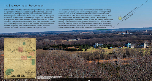
Blue Mound
the landmark blue mound elevation 1052 feet is composed of the same rock material as this hill long ago these 2 points were part of a common plateau. In the 1970s blue mound briefly sported the ski slope named mount blue which included an artificial snow machine.
Eudora
In 1857 a German settlement company bought 774 and 1/2 acres from Shawnee chief Pascal fish junior at the confluence of the Wakarusa and Kansas rivers eudora which means beautiful gift. And Greek was named for fishe daughter among eudora settlers were Quaker abolitionists Jewish immigrants who founded a Jewish cemetery in 1858. Catholics who built the Holy Family Catholic Church in 1864 the oldest extant Catholic Church in Kansas and a significant black population whose history parallels the founding of eudora in addition to supporting agriculture. Eudorus business community has included a mineral springs resort a cannery pottery cigar match fruit drying and cheese factories a suspender making business and breweries it has been home to the central protection association. Which continues to host an annual CPA celebration that began in 1901 during World War 2 employees of the sunflower ordinance works caused a population boom and an upgraded road highway 10 made eudora an attractive home for commuters?
The Oregon Trail
The Oregon trail skirted the South side of blue mound then went West along the Ridge between the Wakarusa and Kansas river valleys.
Panel Nine - Baldwin Woods, Sunrise and Moonrise
Transcription of Passerine Audio Tour - Baldwin Woods, Sunrise and Moonrise
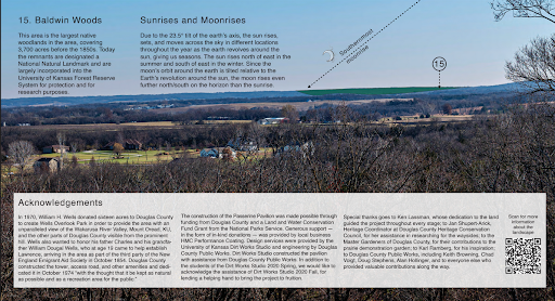
Panel Nine - Baldwin Woods
This area is the largest native Woodlands in the area, covering 3700 acres before the 1850s. Today the remnants are designated a national natural landmark and are largely incorporated into the University of Kansas forest reserve system for protection and for research purposes. Sunrises and moonrises: due to the 23.5-degree tilt of the earth 's access the sun rises, sets, and moves across the sky in different locations throughout the year, as the earth revolves around the sun. The sun rises north of east in the summer and south of east in the winter. Since the moon 's orbit around the earth is tilted relative to the earth 's revolution around the sun, the moon rises even further north or south on the horizon than the sunrise.